Oliva, Safor and Valleys Route
The Oliva, Safor and Valleys Route will take you through spectacular landscapes and challenging mountain passes, as you discover the rich history that surrounds each valley.
A Challenging Journey Through History and Nature
The Oliva, Safor and Valleys Route is one of the most demanding and fascinating in the area. This 88.8-kilometre ride takes us through mountain passes that are little-known to most cyclists but highly appreciated by local riders. Along the way, we traverse the Perputxent Valley, dominated by Perputxent Castle, which has a rich history dating back from the time of the Moors to the Knights Templar. The route also includes passing through Planes de la Baronía, with another Arab castle perched on high, and an ascent to the Margarida mountain pass.
Road Cycling:
Ruta Oliva, Safor & Valleys Route
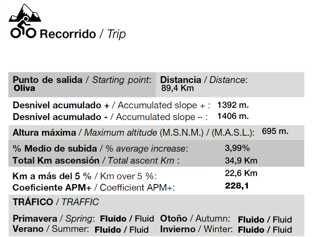
Covering a total distance of 88.8 km, the Oliva, Safor and Valleys Route is a challenging option for cyclists seeking a comprehensive experience. The ride includes a positive elevation gain of 1,500 metres and a negative elevation gain of 1,500 metres, presenting a challenge on both the climbs and the descents. The maximum altitude reached is 695 metres, allowing you to enjoy breathtaking panoramic views of the region. The steep gradients, with some climbs exceeding 16%, make this route ideal for experienced cyclists looking to push their limits while enjoying unparalleled landscapes.
Km distance
Positive Elevation
Negative Elevation
Maximum Altitude
Max elevation: 695 m
The Serpis Greenway, a historic route between l’Orxa and Villalonga


Oliva, Safor and Valles
On this route we are going to do one of the most unknown ports for cyclists who visit us, due to its unknown access from both sides. On the contrary, very well known to Bikers who saw how it went from being a dirt track to a road that ends again in narrow asphalt roads. Their descent towards l’Orxa is done on asphalt in not very good conditions. We will cross the Perputxent Valley, guarded by the Castle with the same name and which passed from the Moors to the Order of the Temple, after their expulsion between the years 1609 to 1613. We’ll pass through Planes de la Baronía, crowned by another Arab castle, before ascending its climb to the Margarida mountain pass and returning via the Gallinera Valley to Pego and Oliva. It’s a fairly tough ride, with gradients exceeding 16%.

Need a Bike for This Route?

City Bike
Designed to offer a pleasant riding experience in urban environments.
From 18€

E-BIKE
Ease of movement, offering smooth and effortless pedaling on inclined terrain.
From 36€

MOUNTAIN BIKE
Designed to deliver exceptional performance on off-road and city routes.
From 18€

ROAD BIKE
Designed to deliver optimal performance on asphalt and cover long distances at high speed.
From 26€
What Do Our Clients Say?
Here you can read first-hand what our clients and friends say about our services. Remember, with us, you have everything you need to enjoy nature through mountain biking — from top-brand MTB bikes and GPS devices to expert guides ready to accompany you on your routes. Whatever you need, we’ve got you covered. Check out the reviews and decide for yourself!
Frequently Asked Questions about our Bicycle Rental
To wrap up, as we know you might have many questions before renting your bicycle, here are some of the frequently asked questions that our customers have before making their decision, or about the doubts that arise before coming to get their bicycle and enjoy our landscapes, city, routes, and hidden places.
If you want more details about our services or have any specific questions, feel free to contact us. We’re here to serve you and support your passion for cycling with exceptional technical service.
What types of bicycles?
We offer a variety of bikes to meet different needs and preferences, including mountain bikes, road bikes, electric bikes, and city bikes. Each type of bike is designed to provide the best experience in its respective environment.
How much does it cost to rent a bicycle?
The cost of renting a bike depends on the type of bike and the duration of the rental. We recommend visiting our pricing section on the website or contacting us for detailed information on current prices.
What do I need to rent a bike?
To rent a bike, it is necessary to present a valid identification, such as an ID card or passport, and sign the rental agreement. In some cases, we may require a security deposit, which will be refunded upon returning the bike in good condition.
What is included in a bicycle rental service?
Our bike rental service includes the selected bike, a helmet, a security lock, and, in some cases, a basic repair kit. Additionally, we offer assistance in case of a breakdown during the rental period.
What should we bring on the bike?
Although we include some basic accessories with each bike, we recommend wearing appropriate cycling clothing, sunscreen, water, and your own tool kit if you plan to do long or demanding routes. It is also advisable to carry a fully charged mobile phone for emergencies and navigation.
What type of bicycle is best for the city?
For urban travel, our city bikes are the best option. They are designed to offer comfort and maneuverability in traffic and are ideal for covering short to medium distances in urban environments.
How do I pay for bicycle rental?
We accept multiple payment methods for your convenience, including credit and debit cards, bank transfers, and cash payments. Upon completing the reservation, the corresponding amount for the selected rental period must be paid. Contact us for more information about payment options and availability.
TELEPHONE
hola@tracksandpedals.es
BIKE WORKSHOP
Bicycle owners have a trusted ally in us, offering you specialized technical service to keep your bike in perfect condition. Repairs, maintenance, and upgrades to ensure your machine is always up to date.
BICYCLE SHOP
Our commitment is to offer you an unparalleled shopping experience, backed by the excellence and passion that define TracksAndPedals. We are the leading reference for bicycle sales in Gandia, Oliva, Safor, and Marina Alta, proudly offering top brands such as Aurum, Cube, Merida, and Rali.
BIKE HIRE
We offer a wide range of high-quality rental bikes so you can enjoy your passion for cycling in Oliva, Safor, Marina Alta, and the Central Counties. Whether you’re looking for a gentle ride along scenic greenways, a thrilling challenge on dream-like roads, or the most demanding single tracks you can imagine — we’ve got the perfect bike for you.


